Bei tollem Wetter führte uns der Weg weiter nach Nevada City, einer weiteren schönen und gut erhaltenen Geisterstadt in Montana.
With the weather being fantastic, we continued to Nevada City—another beautiful, well-preserved ghost town in Montana.
_1.jpg)
Nevada City wurde im Jahr 1863 nach einem bedeutenden Goldfund in Alder Gulch gegründet. Nach dem Abflauen des Goldrausches sank die Bevölkerungszahl allerdings drastisch; während zu besten Zeiten über 2000 Menschen hier lebten, waren es 1880 nur noch 50. Die 1896 gegründete Conrey Placer Mining Company hat das Tal in den folgenden 24 Jahren mittels Schwimmbaggern erneut umgebaggert, um Gold zu finden – ein Prozess, bei dem zahlreiche Gebäude in Nevada City zerstört wurden. Insgesamt wurde im Laufe der Zeit Gold im heutigen Wert von etwa 2,5 Milliarden US-Dollar gefördert. Als später der Highway durch den Ort gebaut wurde, zerstörte das weitere ursprüngliche Gebäude.
In den 1940er- und 1950er-Jahren restaurierte der Denkmalschützer Charles Bovey die Stätte, indem er authentische Gebäude aus der Zeit des "Wilden Westens" aus ganz Montana hierher versetzen ließ. Heute findet man hier ein Freilichtmuseum mit 108 Gebäuden aus der Zeit des Goldrausches (davon 14 am ursprünglichen Standort) sowie die größte Sammlung historischer mechanischer Musikautomaten in Nordamerika. Der Ort ist mit seiner Schwesterstadt Virginia City über die "Alder Gulch Shortline Railroad "verbunden.
Nevada City was founded in 1863 following a significant gold discovery in Alder Gulch. As the gold rush subsided, the population dropped sharply; during its heyday, more than 2,000 people lived there, but by 1880 only 50 remained. The Conrey Placer Mining Company, established in 1896, spent the next 24 years dredging the valley with floating excavators in search of gold—a process that destroyed numerous buildings in Nevada City. In total, the area yielded gold worth about $ 2.5 billion (at today’s value).today's building a highway through the town destroyed even more original structures.
During the 1940s and 1950s, preservationist Charles Bovey restored the site by relocating authentic "Wild West"-era buildings from across Montana to the town. Today, it serves as an open-air museum featuring 108 gold-rush-era buildings—14 of which remain in their original locations—as well as the largest collection of historical mechanical musical instruments in North America. The town is connected to its sister city, Virginia City, by the "Alder Gulch Sh"rtline Railroad."
_1.jpg)
Auf dem Schild an der Straße sieht man auch den Schriftzug " Home of the Montana Vigilantes 3-7-77". Ein "Vigilante" ist ein Mitglied einer Bürgerwehr, also eine Person, die ohne jegliche rechtliche oder offizielle Befugnis versucht, Verbrechen zu verhindern, Straftäter zu fassen oder sie zu bestrafen. Für die Zahlenkombination gibt es verschiedene Erklärungen.
1.
Die Zahlen stehen für das Datum, an dem in Bannack, Montana – dem ersten Justizstandort des Bundesstaates – der „Eid der Vigilante“ (Vigilante Oath) unterzeichnet wurde. Diese Annahme wird durch einen vermeintlichen Eid gestützt, datiert auf den 7. März 1877, der in Bannack an der Wand der Freimaurerloge „3-7-77“ hängt.
2"
Die Zalen geben die Maße eines Grabes an: 3 Fuß × 7 Fuß × 77 Zoll. (Diese Erklärung ist die gängigste.)
3.
Ein Beschuldigter hat drei Stunden, sieben Minuten und siebenundsiebzig Sekunden Zeit, um zu verschwinden – andernfalls droht Gewalt.
Interessant ist hierzu auch, dass die Zahlenkombination auf dem Ärmelabzeichen der Montana Highway Patrol zu finden ist, als Ehrung an jene ersten Männer im Montana-Territorium, die sich für die Sicherheit und das Wohlergehen der Bevölkerung einsetzten. Man findet das Symbol auch auf den Fliegerkombis der Piloten der Montana Air National Guard sowie auf dem Abzeichen der Medevac-Einheit 1189th GSAB – „Vigilantes“ – der Montana Army National Guard.
On the roadside sign, one can also see the inscription "Home of the Montana Vigilantes 3-7-77." A "vigilante" is a member of a self-appointed group—an individual who, without any legal or official authority, attempts to prevent crime, apprehend offenders, or administer punishment. There are several explanations for this numerical combination:
1.
The numbers represent the date on which the "Vigilante Oath" was signed in Bannack, Montana—the state's first seat of justice. This theory is supported by a purported oath, dated March 7, 1877, which hangs on the wall of the Masonic lodge in Bannack.
2.
The numbers indicate the dimensions of a grave: 3 feet × 7 feet × 77 inches. (This is the most common explanation.)
3.
An accused person is given three hours, seven minutes, and seventy-seven seconds to leave—otherwise, they face the threat of violence.
Interestingly, this numerical combination also appears on the sleeve patches of the Montana Highway Patrol, serving as a tribute to those early men in the Montana Territory who worked to ensure the safety and well-being of the population. The symbol can also be found on the flight suits of pilots in the Montana Air National Guard, as well as on the insignia of the 1189th GSAB—a medevac unit of the Montana Army National Guard known as the "Vigilantes."
_1.jpg)
Das grosse Outdoor-Museum kostet $10 Eintritt pro Erwachsenen und ist es definitiv wert. Gleich hinter dem EIngang sieht man die grosse Sammlung wirklich toller Musikautomaten verschiedenster Grössen.
The large outdoor museum costs $10 per adult and is definitely worth it. Just past the entrance, you can see a large collection of truly fantastic mechanical musical instruments of all different sizes.
.jpg)
Verlässt man das Gebäude, gelangt man auf das Außengelände und kann die meisten dort zusammengeführten Gebäude auch von innen ansehen.
Upon leaving the building, you reach the outdoor grounds, where you can also view the interiors of most of the structures assembled there.
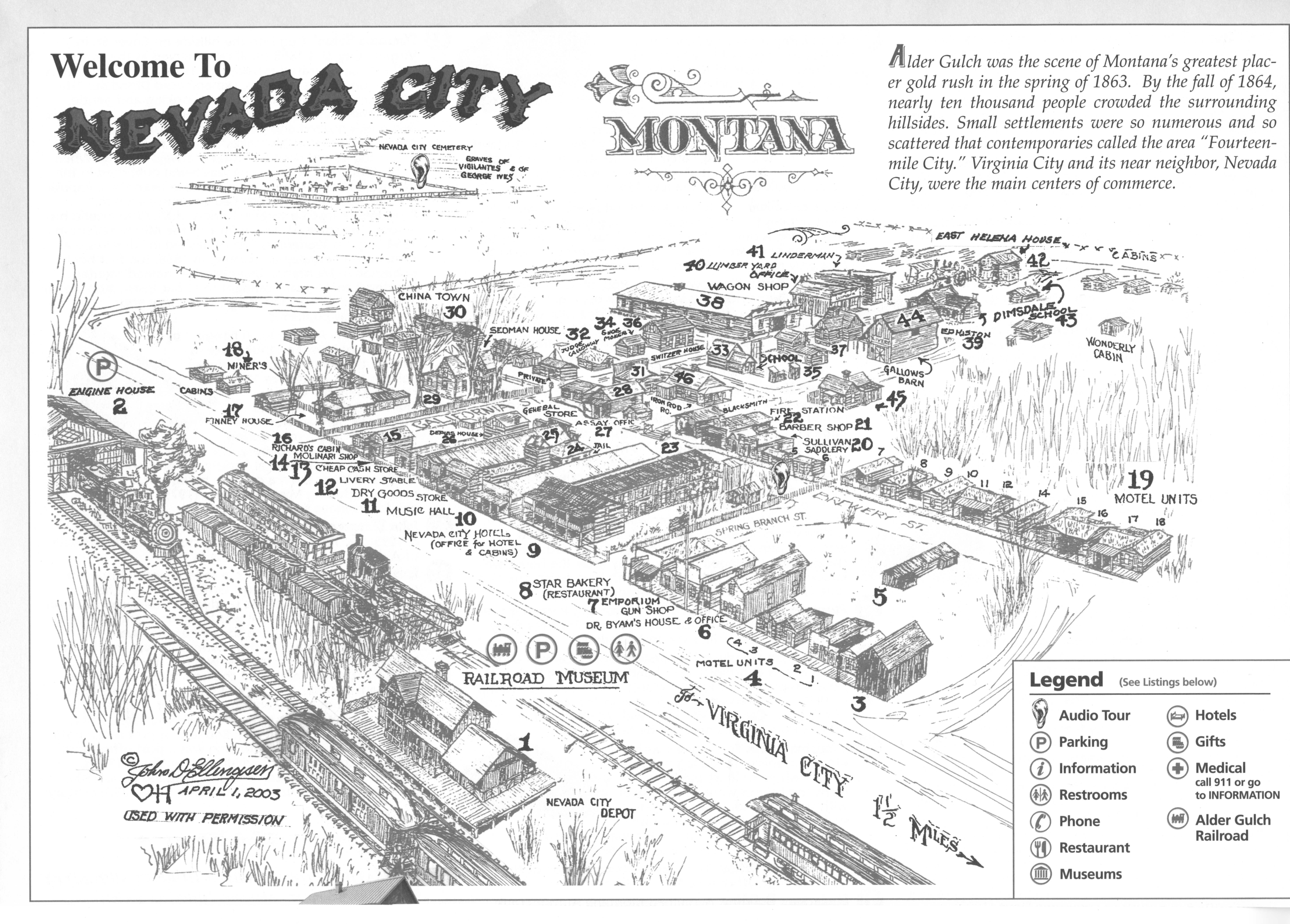
Karte/map:

_1.jpg)
.jpg)
Blick in den Friseur (21)/ view inside the barber shop (21)
.jpg)
Saloon/ General Store (25)
.jpg)
.jpg)
Post office (46)
.jpg)
.jpg)
ganz rechts sieht man die Gallow Scheune (44)
on the right: Gallow Barn (44)
_1.jpg)
Hier sieht man das Schulgebäude (35) mit einer Schaukel daneben, 2 Plumpsklos und einer Wasserpumpe. Im größeren Teil war der Schulraum untergebracht, im kleineren Teil war das Zimmer, in welchem die Lehrerin wohnt.
Here you can see the school building (35), with a swing next to it, two outhouses, and a water pump. The larger section housed the classroom, while the smallteacher'sn contained the teacher's room.
_1.jpg)
.jpg)
.jpg)
links das Holzgeschäft (41), rechts das Linderman-Gebäude (40)
left: Lumber Yard Office (41), right: Linderman House (40)
.jpg)
Kutschen-Händler & Werkstatt (38)
wagon shop (38)
.jpg)
.jpg)
.jpg)
Richter GaGalloway'sus (32)
Judge Galloway's house (32)
.jpg)
.jpg)
_1.jpg)
Sheriff (31)
.jpg)
.jpg)
.jpg)
Ein Blick auf das sogenannte "Chinatown", die Ecke, in der chinesische Arbeiter wohnten und Geschäfte hatten. Hier wurden u.a. Körbe und Särge hergestellt, Waffen verkauft, die Wäsche gewaschen und Lebensmittel verkauft. (30)
A look at the so-called "Chinatown"—the area where Chinese workers lived and also ran businesses. Here, among other things, they crafted baskets and coffins, sold weapons, washed laundry, and sold groceries. (30)
_1.jpg)
.jpg)
.jpg)
.jpg)
Sedman House (29)
.jpg)
.jpg)
.jpg)
.jpg)
.jpg)
Kleines-Geld-Laden (13)
Cheap Cash Store (13)
.jpg)
.jpg)
Ein Schild informiert über die Filme, die hier in der Gegend gedreht wurden.
A sign provides information about the films that were shot in this area.
_1.jpg)
Hotel (9)
.jpg)
Vom Bahnhof in Nevada City faehrt ein kleiner Zug die kurze Distanz zur Nachbarstadt Virginia City, ebenfalls eine ehemalige Minenstadt. Wir machten uns den Spass und fuhren die Tour. Hin und zurueck ca 1h wobei darin 20min Aufenthalt am Bahnhof der Schwesternstadt inkludiert sind, waehrend der Fahrt erfaehrt man viele Dinge zu den beiden Staedten.
From the station in Nevada City, a small train travels the short distance to the neighboring town of Virginia City—also a former mining town. We decided to have some fun and took the trip (a round trip lasting about an hour, which includes a 20-minute stop at the station in the sister town), during the journey, you learn many things about the two cities.
_1.jpg)
.jpg)
.jpg)
_1.jpg)
.jpg)
.jpg)
Diese Geroellberge sind das Ergebnis von dem Goldbagger als er durch den Fluss pfluegte.
These piles of rubble are the result of the gold dredge as it plowed through the river.
.jpg)
.jpg)
Bahnhof Virginia City/ train station Virginia City
Am Bahnhof bleibt genuegend Zeit in den kleinen Souvenirladen und Coffee Shop zu gehen.
At the train station, there is enough time to visit the small souvenir shop and coffee shop.
.jpg)
.jpg)
.jpg)
Als wir zurueck waren, ging es dann mit dem Camper weiter nach Virginia City. Wir verbachten knapp 2.5 Stunden in Nevada City, um uns in Ruhe die Gebaeude anzuschauen und die Schilder zu lesen, es war wirklich ein gelungener Besuch. Auf der Webseite von Nevada City kann man mehr ueber die Stadt erfahren sowie auch eine virtuelle Tour durch die Stadt machen. Ich hab mich bei meinen Nummerierungen an der Schwarz-Weiss Karte orientiert, waehrend der virtuelle Rundgang eine teils andere Nummerierung hat. Aber dort erfaehrt man auch den Hintergrund zu den verschiedenen Gebaeuden.
Once we were back, we continued on to Virginia City in the camper. We spent just under 2.5 hours in Nevada City, taking our time to look at the buildings and read the signs; it was a truly enjoyable visit. You can learn more about Nevada City on its website, which also offers a virtual tour of the town. My numbering system is based on the black-and-white map, whereas the virtual tour uses a somewhat different numbering scheme; however, the tour does provide background information on the various buildings.